Posts with tag 'Places to See in Central Oregon'
Subscribe and receive email notifications of new blog posts.
 RSS Feed
- 2026 | 73 Posts
- 2025 | 103 Posts
- 2024 | 110 Posts
- 2023 | 72 Posts
- 2022 | 52 Posts
- 2021 | 70 Posts
- 2020 | 84 Posts
- 2019 | 38 Posts
- 2018 | 48 Posts
- 2017 | 39 Posts
- 2016 | 31 Posts
- 2015 | 10 Posts
12
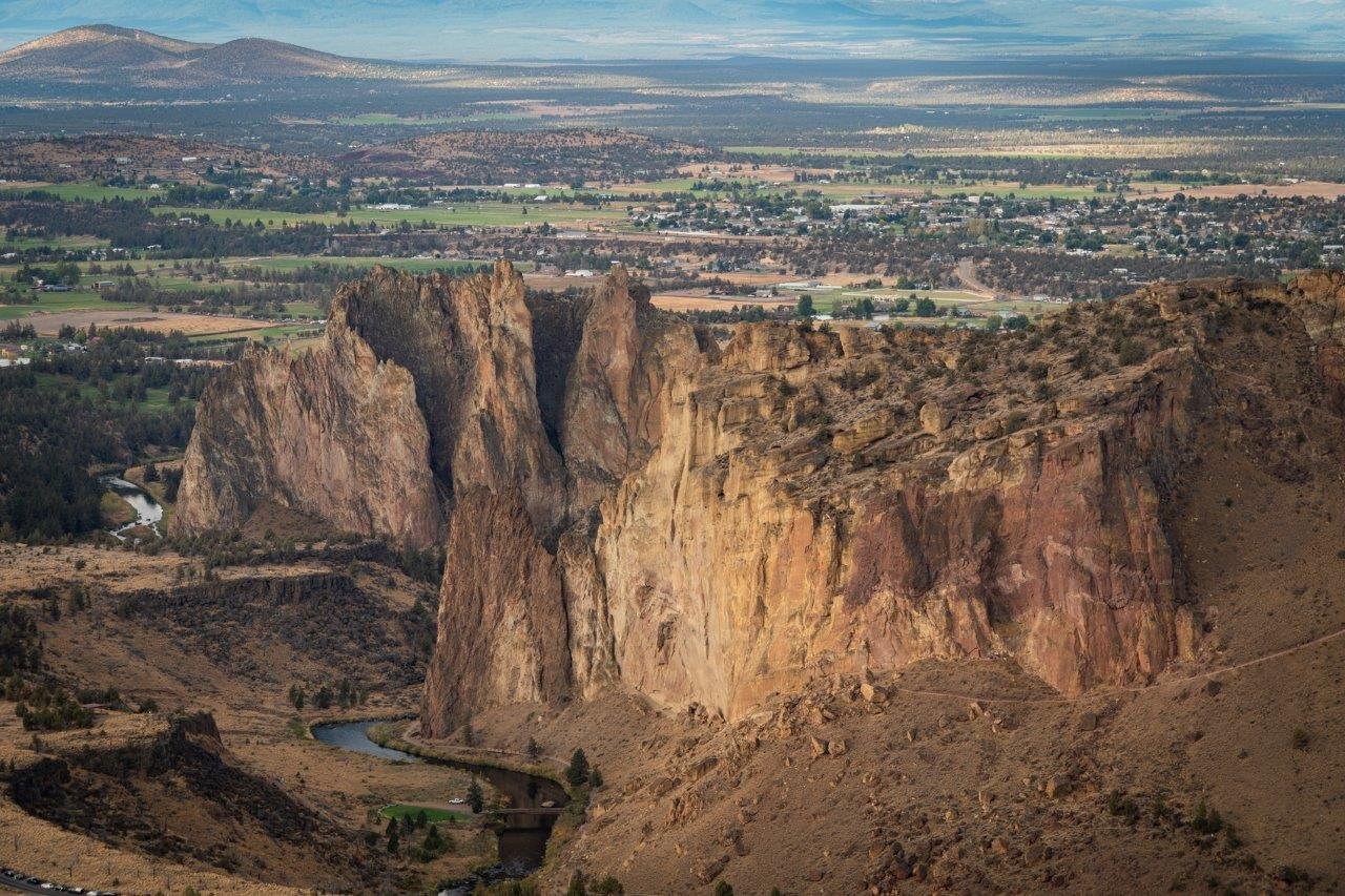
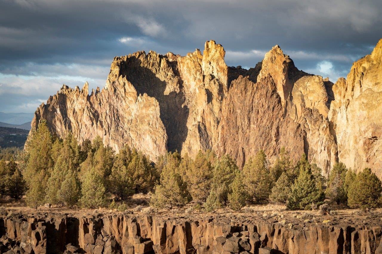
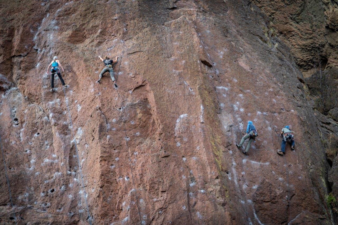
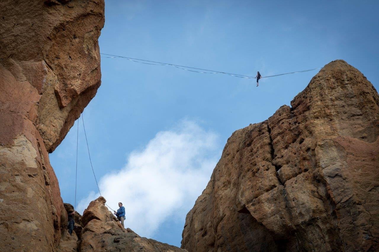
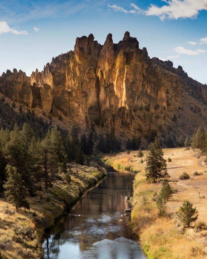
Smith Rock's Burma Road is the Trail Less Taken
Smith Rock is One of Oregon's Most Popular State Parks
If you are planning on seeing one of Oregon's most popular state parks, be sure to get there early. Smith Rock, located north of Redmond and just east of Terrebonne, is an extremely popular destination for most visitors to Central Oregon as well as those locals just looking to recreate, hike, or rock climb. The iconic rock formation is credited as being the birthplace of modern American sport climbing and is popular with traditional, multi-pitched and bouldering as well with over 1800 rock climbing routes within the park. Most visitors who are not climbers, will hike on many of the trails scattered around the park, some along the Crooked River and others over the rocks - the most popular being Misery Ridge.
Last Sunday we took a longer hiking route we had never done before - the full 7.5 mile loop around the park which included the Canyon Trail to Wolf Tree to Homestead to Burma Road to Summit Trail to River Trail. The total elevation gain was 1200 feet and we did the hike counter clockwise in order to climb the steep, but not difficult Burma Road which brings you to the high point of the hike early in the day. We arrived at the park before 8 am and already there were many cars parked in the limited parking lot. We paid our $5 park fee and enjoyed the morning hiking. The views after the rain the night before were wonderful and the clean air after the wildfire haze most welcome. The Cascades were hidden behind clouds, but every now and then we could catch a view of one of the peaks scattered with fresh snow.
 |
 |
 |
 |
 |
 |
6
The South Sister Hike is For the Destination

South Sister is a Challenge!
Probably one of the most hiked mountains in the Cascades, South Sister, while not a technical hike, is a challenge. In roughly 5.5 miles, hikers climb 5000 feet to the summit of Oregon's third highest peak at 10,358 feet. In the 35 years we have lived in Bend, we had never hiked South Sister until Saturday, October 3, 2020, thinking that the normal summer crowds would be gone by then. We were surprised to find out that was not the case.
We started our hike at Devil's Lake off Cascade Lakes Highway at 6:45 am. The first mile and a half was in wooded old growth forest, but the trail climbed steeply through the hemlocks and opened up once we reached the plains overlooking Moraine Lake. There the view of South Sister became prominent. Even that early in the morning we met people coming down from the mountain, having enjoyed watching the sunrise from the peak.
Past Moraine Lake, the rocky trail started to climb steeply. We had to carefully watch where we stepped and made sure our footing was secure. There was several places where the trail wasn't clearly defined and we had to pick and choose our way up the mountain. Climbing up over a moraine, we reached the final stop before the last push up the saddle to the summit at Lewis Glacier and its lake. The trek to the top is very slow and steep with loose rock and cinders - and on the trip down many, many people to step around. Once we passed 10,000 feet, we got above the inversion that moved into Central Oregon with high pressure and trapped smoke from the wildfires still burning in the area. This impacted our views from the top - which we have been told are fabulous for hundreds of miles - but did create interested images to see the effect of smoke and bad air quality.
According to forest service personnel, starting next year, the hike up South Sister will be by permit only to limit the number of people on the mountain at one time. Based on our experience, that will be a positive move. The hike is challenging enough, but it can be dangerous having to step around people on parts of the trail where loose stones and cinders along with steep slopes can create hazardous situations. We returned to our car at 5 pm, having taken all day to hike up and back the 5000 feet with sore muscles but satisfaction at finally having reached the summit.
 |
 |
 |
 |
 |
 |
30
Tumalo Falls is Bend's Waterfall
Popular Tumalo Falls is Among Most Tourists' Must See Destinations
 Tumalo Falls has always been a destination for people visiting Central Oregon. The short drive out of Bend followed by a short walk can give tourists the opportunity to see a beautiful local waterfall and the location of roughly 1/2 of Bend's water supply. Most people stop at either the base of the falls, or will climb the 1/4 mile up to the overlook at the top of the falls. But there is a fabulous trail upstream along Tumalo Creek that takes hikers past several beautiful waterfalls and eventually leads to Happy Valley meadow in which a merger of several trails and roads provide for miles of opportunities to recreate using the Tumalo Trail System.
It has been seven years since we last hiked to Tumalo Falls. That last time the road to the falls was closed due to the piping project for the the city of Bend in the Bridge Creek watershed. At that time we parked at Skyliner's Trailhead and hiked around to Tumalo Falls and then hiked up Bridge Creek, eventually joining with the main North Fork Trail just south of Happy Valley returning down the main trail and eventually back to our car. During that trip we saw almost no one.
It was very different September 26, 2020. Parking along the road was crowded and rather than hike the normal way up the North Fork Trail, we decided to take the loop around using the Farewell Trail which starts on the east side of the Falls and switchbacks up the hill bordering Tumalo Falls on the east, eventually joining with Mrazek Trail, then to Metolius-Windego Trail and then in Happy Valley, connecting with the North Fork Trail; the whole hike was slightly more than 10 miles and gave us a much different perspective of the area.
Unlike our last experience seven years ago, however, we were very surprised at how busy the trail was - not with hikers, but with mountain bikers. During our 10 mile loop, we stepped aside multiple times as mountain bikers passed by. We estimate we saw over 100 bikers that day and obviously during the summer season, there must be many, many more that will ride over these trails. The Tumalo Trail System borders the Three Sisters Wilderness where bicycles are not allowed and the system is extremely extensive and must be well enjoyed by the mountain bike community in Central Oregon.
 |
 |
.JPG) |
 |
.JPG) |
22
Is The Obsidian Trail Worth the Wait?
Hikers Must Reserve Their Day Months in Advance

We had heard about the Obsidian Trail for years, and how hard it is to reserve a time to hike it. Located in the Willamette National Forest off Hwy 242 (McKenzie Pass), access to the Obsidian Trail is limited - first due to Hwy 242's annual closure from October through the middle of June - and second due to demand for the hard to get passes which limit use to 30 day hikers and 40 overnight visitors. We reserved our time 2 months in advance, hoping the weather and wildfires would cooperate with our hike. The Green Ridge Fire and the Lions Gate Fire were both burning On September 5, 2020 when we took our hike, but neither had yet exploded into the heavy wildfires that burned much of McKenzie Canyon and caused the choking smoke that is still impacting Oregon.
We arrived very early at the trailhead, just past sunrise, and were surprised how few cars were parked in the parking lot. But this does make sense. When you have to reserve your time so far in advance, scheduled recreational hikes may have to give way to changes in financial or personal circumstances thus bringing use of the trail to even fewer people. During our Obsidian Trail hike, we past two parties who had spent the night in the area and were hiking out plus were past by a party packing in with horses. Other than these people, we saw no one else on the Obsidian Trail except for a party hiking in at the end of the day as well as a second group of people packing with horses. However, the Obsidian Trail loop, if taken, does utilize the Pacific Crest Trail where we saw a number of day users and backpackers.
The Obsidian Trail is named for the obsidian stones and pebbles which are very evident in certain areas of the hike - and which will glitter beautifully when the sun hits them. The hike gains 2139 feet in elevation and provides for stunning views of North and Middle Sister, including vistas of Collier Glacier. Obsidian Falls and wonderful lodgepole and hemlock forests are also treats to see along the way. Lava fields, mountain meadows, small alpine lakes and, when the loop is followed, views of Mt. Washington, Three Fingered Jack and Mt. Jefferson are also visible. We also saw the smoke from the Green Ridge Fire, but it did not impact our enjoyment of the area during the day. The full loop was just under 12 miles, but we did take a side trip up the flank of Middle Sister, hoping to find the trail which we have heard exists to the summit, but failed to locate it.

 |
 |
 |
1
Sisters Mirror Lake to Wickiup Plains Hike Offers Lakes and Mountains
Last Saturday, August 29th, we decided to take an easier hike to Sisters Mirror Lake. Located just south of Devil's Lake off South Century Drive, the Sisters Mirror Lake trail head has limited parking space, but we easily found a spot on the highway. The 3 plus mile hike into Sisters Mirror Lake was a fairly easy walk in old growth forest with an elevation gain of between 600 and 700 feet. The lake itself is one of a series of small high elevation lakes, each with its own charm and privacy. We saw just a few people on this trip - many with packs to spend the night.
After enjoying visiting the various lakes, including Lancelot, Camelot, Needle and several unnamed lakes and snacking on wild blueberries that were at their peak of ripeness, we traveled on the Pacific Crest Trail, which skirts Sisters Mirror Lake, to Wickiup Plains having heard that the Plains provide wonderful South Sister views. That statement was proven true when we stepped out of the old growth forest and saw South Sister. The south side of South Sister rises dramatically up from the Wickiup Plains and dominates the skyline. The view is truly magnificent and with each step closer to the Wickiup Point, the view grew larger.
We took the Wickiup loop back, connecting with the Devil's Lake trail before taking the Elk Lake trail back to connect with the Sisters Mirror Lake trail roughly 1/2 a mile before the parking lot. Wonderful views of Broken Top were visible on this part of our hike before we entered the old growth forest again. All in all, our relatively easy hike ended up being in excess of 12 miles - but it was well worth it for the wonderful surprises we saw. We have lived in Bend since 1985 but have never heard of Wickiup Plains before. What a surprise!
 |
 |