Posts with tag 'Hiking Central Oregon'
Subscribe and receive email notifications of new blog posts.
 RSS Feed
- 2026 | 72 Posts
- 2025 | 103 Posts
- 2024 | 110 Posts
- 2023 | 72 Posts
- 2022 | 52 Posts
- 2021 | 70 Posts
- 2020 | 84 Posts
- 2019 | 38 Posts
- 2018 | 48 Posts
- 2017 | 39 Posts
- 2016 | 31 Posts
- 2015 | 10 Posts
2
Morning on the river. Afternoon on the mountain. A day in Central Oregon that feels just right.
Morning on the River, Afternoon on the Mountain
This is one of those days that reminds you why Central Oregon is hard to beat.
Start your morning on the Deschutes River Trail, easily accessed on Bend's West Side at
24
Hike Iron Mountain in Winter for a Wonderful Experience
Hiking the Winter Cascades January 2026
It is typically challenging to hike in the Cascades in winter. When snow piles up, those who venture into the mountains normally utilize snowshoes or skis to access the higher trails. However, January 2026 has been unusual for warm days with little snow. As a result, some of those trails that most people hike in summer can be hiked in winter, providing for experiences that few have.
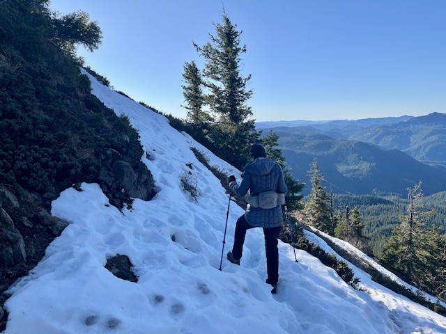
On January 24, 2026, the trailhead to Iron Mountain was snow free. Located on Highway 20 at Tombstone Pass, the hike to Iron Mountain is favored by many residents in Central Oregon and the Willamette Valley as a wonderful place to see wildflowers in the spring/summer. Over 300 species of wildflowers have been identified on Iron Mountain and the summertime traffic to see these can create crowded trails. However, in winter few hike the trail when snow makes it challenging. But in January 2026, with warm weather and limited snow, the trail had very few people and just a few icy snow patches, most near the top of the mountain. Microspikes and trekking poles made it easier to summit the mountain with much of the trail remaining free of snow. The entire hike up and back from the Browder Ridge parking area was just under 4 miles with just over 1400 feet of elevation gain. The long term weather forecast does not anticipate a lot of snow the rest of January, but perhaps in February there may be more precipitation.
 |
 |
 |
 |
9
Bend Premier Real Estate | December 2025 Newsletter
What's in the December 2025 Bend Premier Newsletter?
- Buyer Activity Picks Up as New Listings Fall
- Layered Peppermint Hot Chocolate Jar
- Holiday Electrical Safety: Preventing Overloaded Outlets and Fire hazards
- Chush Falls in Winter is Beautiful
- Your Roadmap to Homeownership
21
Is Bend a Good Place to Live? The Real Year-Round Lifestyle Guide
Thinking about making a move to Bend? You're not alone. Every year, thousands of people from Portland, Seattle, and the Bay Area explore what life might look like in Central Oregon's high desert—drawn by sunshine, mountains, and a lifestyle that feels equal parts active and intentional.
This guide is your honest, year-round look at what living in Bend is really like—season by season, neighborhood by neighborhood, and day to day—so you can decide if Bend fits the way you want to live.
The Big Picture: Why People Choose Bend
Bend's appeal goes far beyond pretty scenery. What truly hooks people is the quality of life—a blend of outdoor recreation, friendly neighborhoods, a slower pace, and the ability to actually enjoy the life you work so hard for.
You'll hear newcomers say things li...
18
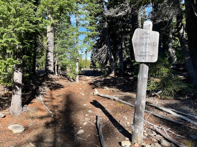
Hiking From Todd Lake to No Name Lake on Broken Top: A Classic Bend Adventure
Why This Hike Tops the List
If you're looking for a high-country hike near Bend that delivers big rewards without being an all-day grind, the Todd Lake to No Name Lake route is hard to beat. It's a staple for locals and a must-do for hikers visiting Central Oregon. Clear views, striking geology, and a turquoise lake tucked under Broken Top's cliffs—this trail earns every bit of its reputation.
Trailhead: What to Know Before You Go
Todd Lake is the gateway to the high country and a gentle start to an otherwise rugged hike. Summer permits are required, and parking fills up early—no sense pretending luck will save you. Get there ahead of the crowd and you'll have a smoother day.
The hike begins with calm lakeside views, but you'll leave the easy terrain behind quickly. Plan for a steady climb and pack more water than you think you need. That rule never goes out of style in the Cascades.
 |
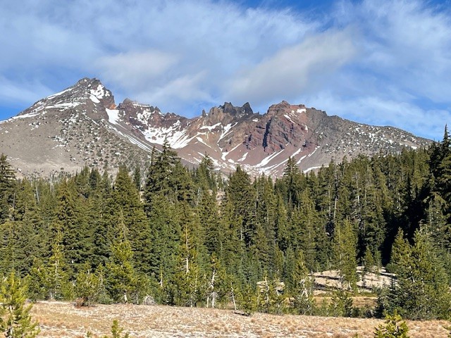 |
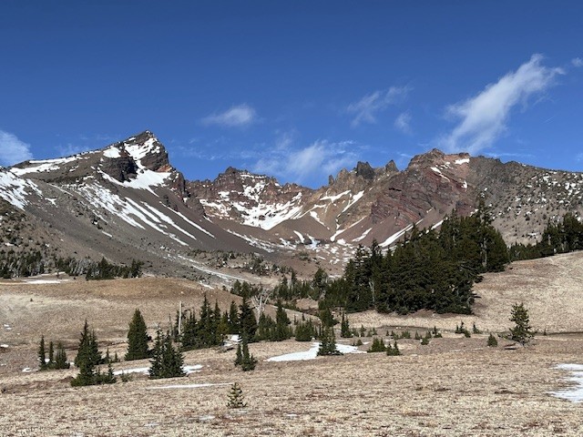
The Ascent Toward Broken Top
Once you climb out of the Todd Lake basin, the landscape immediately shifts. Broad alpine meadows open up with views that practically force you to stop. Wildflowers linger into late summer, and depending on the year, you might hit a few water crossings early in the season. Some are simple; some will test you and a short jaunt upstream may find a better crossing.
The trail continues uphill at a consistent grade—not brutal, but enough to remind you you're earning the views. As the trail climbs, you will see the bowl of Broken Top and Broken Hand next to Ball Butte.
 |
 |
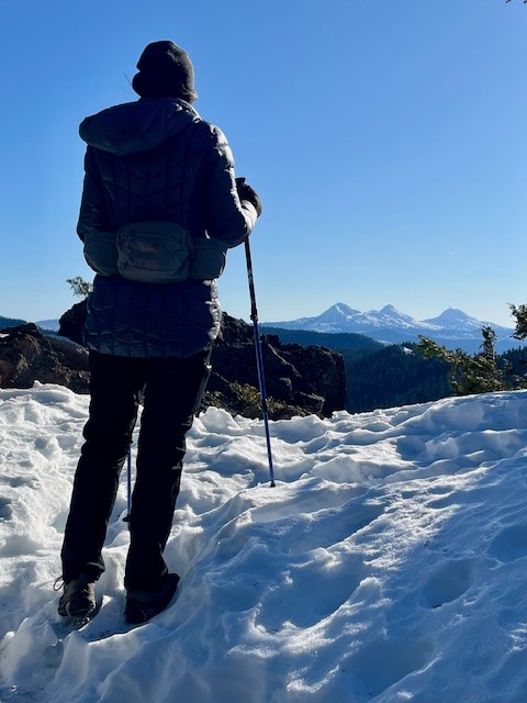
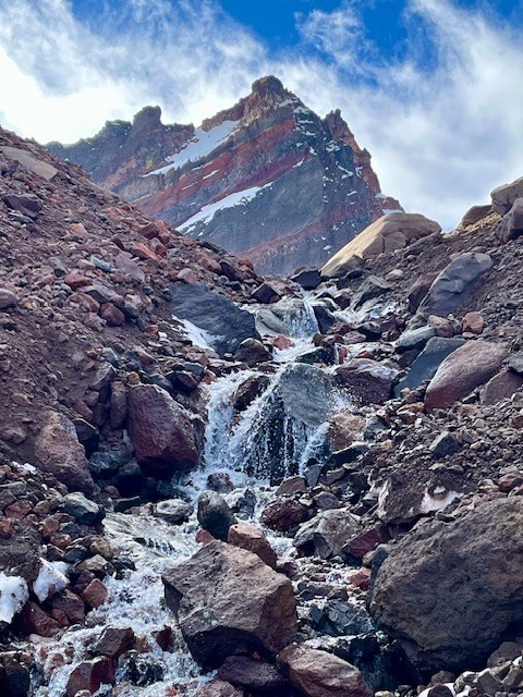
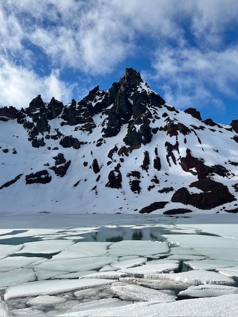
Arriving at No Name Lake
The payoff is no mystery. As soon as you crest that final rise, No Name Lake jumps into view with its glacial-blue water and the jagged summit of Broken Top looming overhead. It's dramatic, and it never gets old.
The wind at the lake can cut right through you, even on sunny days. Bring the extra layer. Most people wish they had. In mid November 2025, early snow melt can make for icy patches.
 |
 |
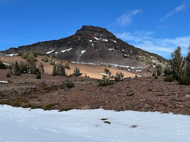
Optional Spur: The Ridgeline Viewpoint
If you've still got energy, take the short scramble above the lake. The vantage point gives you a panorama of South Sister, Mount Bachelor, Sparks Lake, and miles of wilderness you won't see from below. It's a quick effort with a huge return.
Heading Back
The descent is straightforward, but the dusty volcanic soil can get slick in summer. The meadows look completely different on the way down, especially in late-afternoon light, so the return trip isn't just a repeat.
Is This Hike Worth It? Absolutely.
There's a reason people go back year after year. It's not technical but the scenery is top-tier. For anyone seeking a dependable alpine hike near Bend with big visual impact, Todd Lake to No Name Lake delivers. The entire trip exceeds 13 miles round trip and over 2500 feet of elevation gain if the Ridgeline Viewpoint is included.
Thinking About Moving to Bend?
If exploring trails like this is the lifestyle you want more of, Bend makes it easy. The area combines year-round outdoor access with a strong community with great real estate opportunities for varied budgets and housing needs. Call us to keep up with local trails, Bend living tips, and Central Oregon real estate insights.