Posts in category 'Why We Love Central Oregon'
Subscribe and receive email notifications of new blog posts.
 RSS Feed
- 2026 | 72 Posts
- 2025 | 103 Posts
- 2024 | 110 Posts
- 2023 | 72 Posts
- 2022 | 52 Posts
- 2021 | 70 Posts
- 2020 | 84 Posts
- 2019 | 38 Posts
- 2018 | 48 Posts
- 2017 | 39 Posts
- 2016 | 31 Posts
- 2015 | 10 Posts
1
The Wildflowers are Blooming at Iron Mountain!
Iron Mountain is a Must Do Hike for Many

We first heard about Iron Mountain 5 years ago when a friend told us about this amazing hike in the Central Cascades off Hwy 20 near Tombstone Summit. When we took the hike, it was past the peak time for the annual wildflowers, but this year the flowers were blooming and the views were stunning.
If you have never hiked Iron Mountain before and are up for several miles, we suggest you park at the Tombstone Summit parking lot, walk 15 minutes through the beautiful nature trail which begins at the end of the lot (bear left down the trail off the gravel road), and then carefully cross the highway to the start of the Cone Peak Trail. This trail takes you gradually up in elevation through old growth forest until the trail opens into stunning fields of wildflowers. Continue along the trail, back and forth into the forest and out until you come to the branch to climb to the top of Iron Mountain. This steep trail is well traveled and eventually brings you to the top where a fire lookout used to be, but now is set up as a sitting area with Cascade mountain locates. After enjoying the view, climb down and continue the loop back through old growth forest to the official Iron Mountain parking lot (careful crossing the highway again). Once we crossed the highway, there was an easily missed path that takes you shortly to a sign going right to the Iron Mountain parking lot or left to the Old Santiam Wagon Road. We walked .3 miles on the Old Santiam Wagon Road (again bear left) to the Tombstone Summit parking lot to get back to our car, climbing steeply at the end. The entire hike was 6.9 miles with roughly 1900 foot elevation gain. This was a wonderful hike at a great time of year.
 |
 |
 |
 |
29
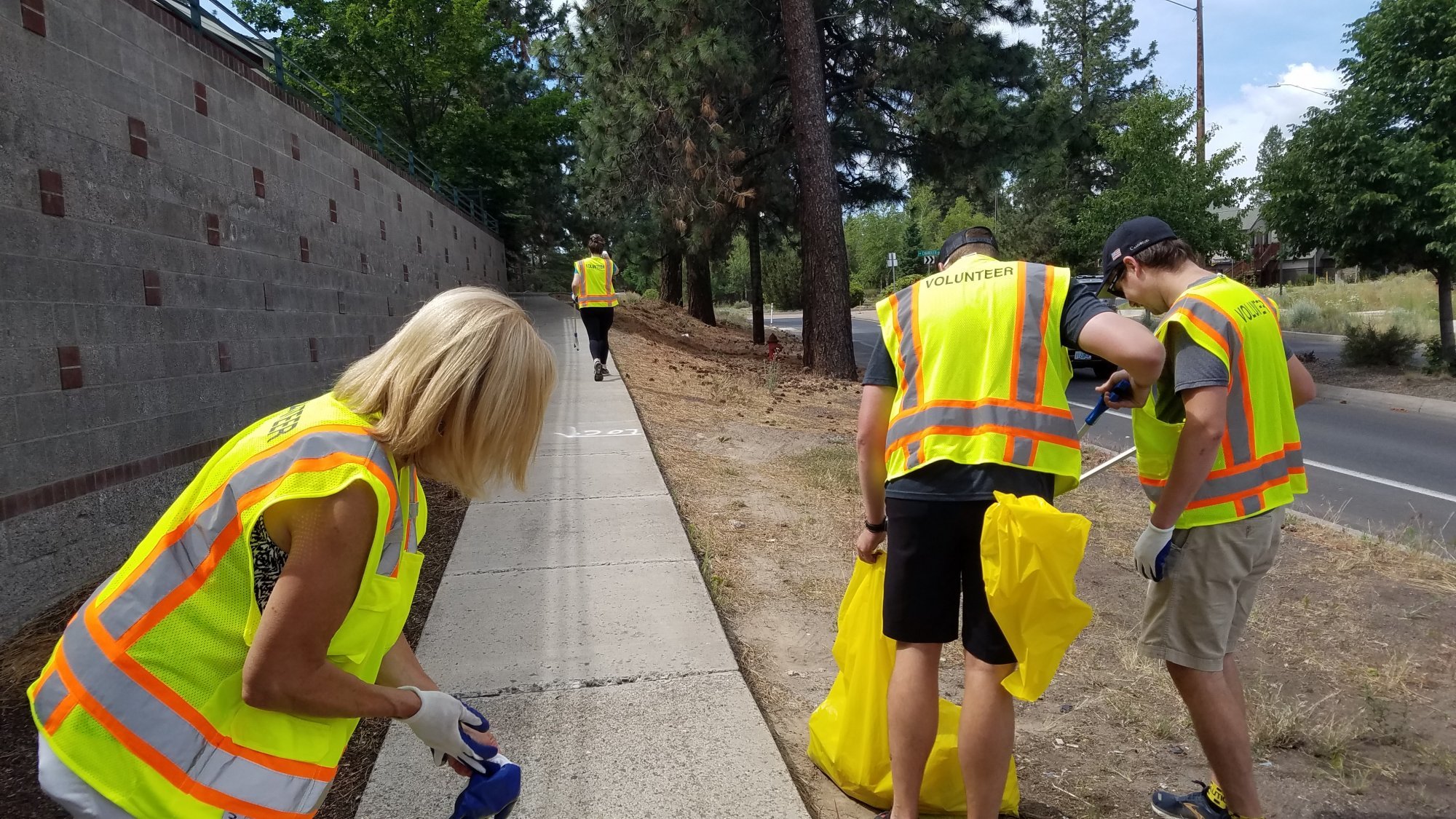
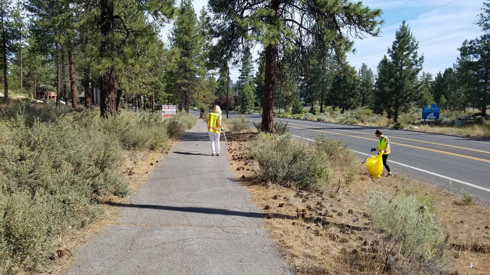
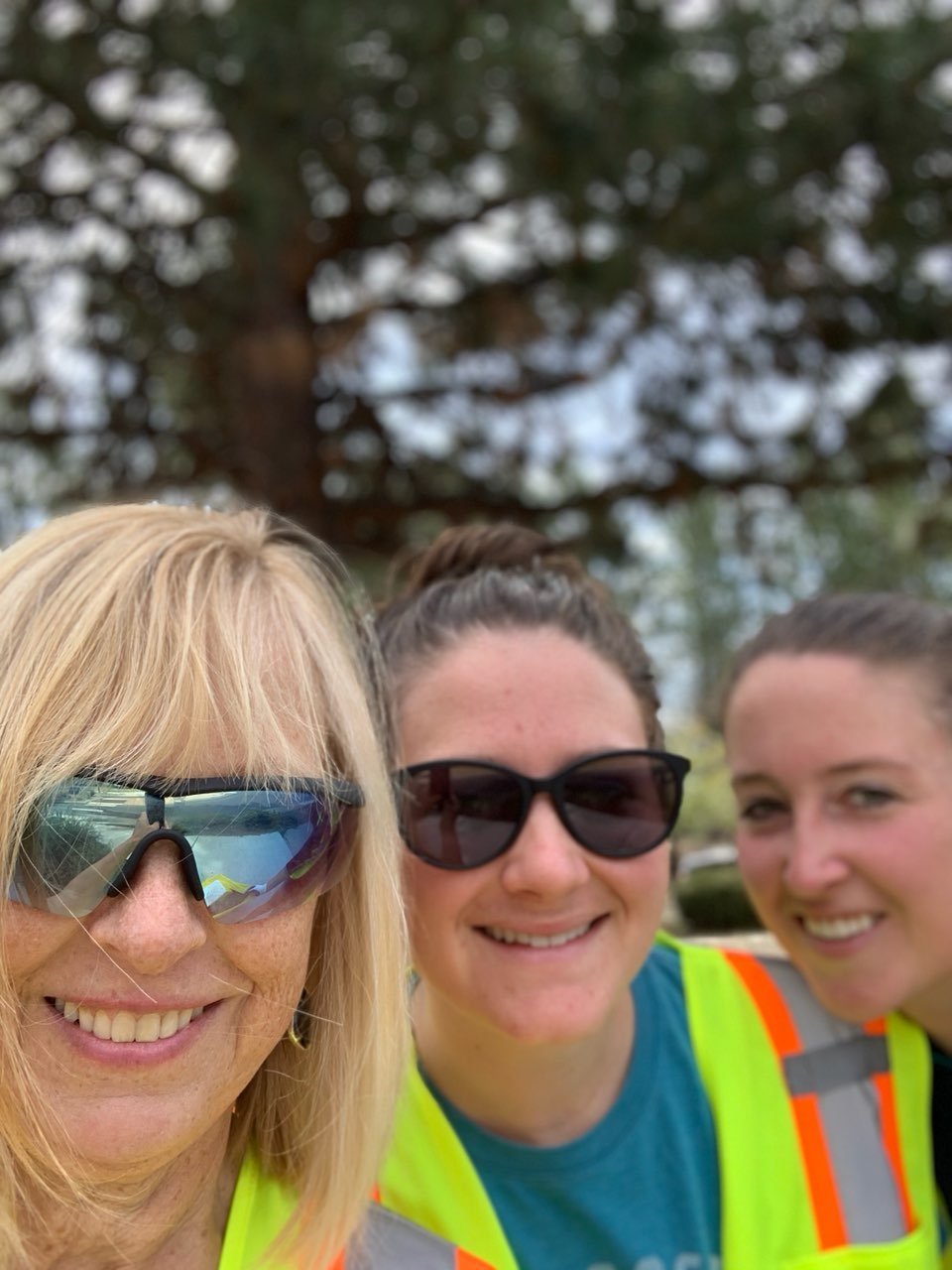
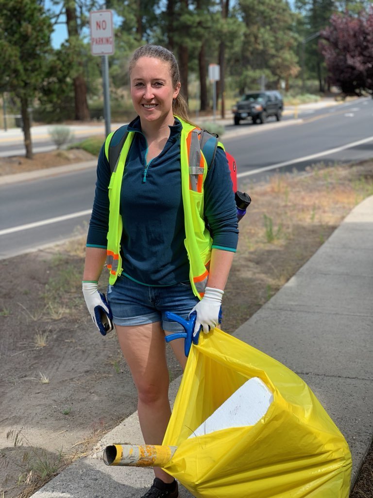
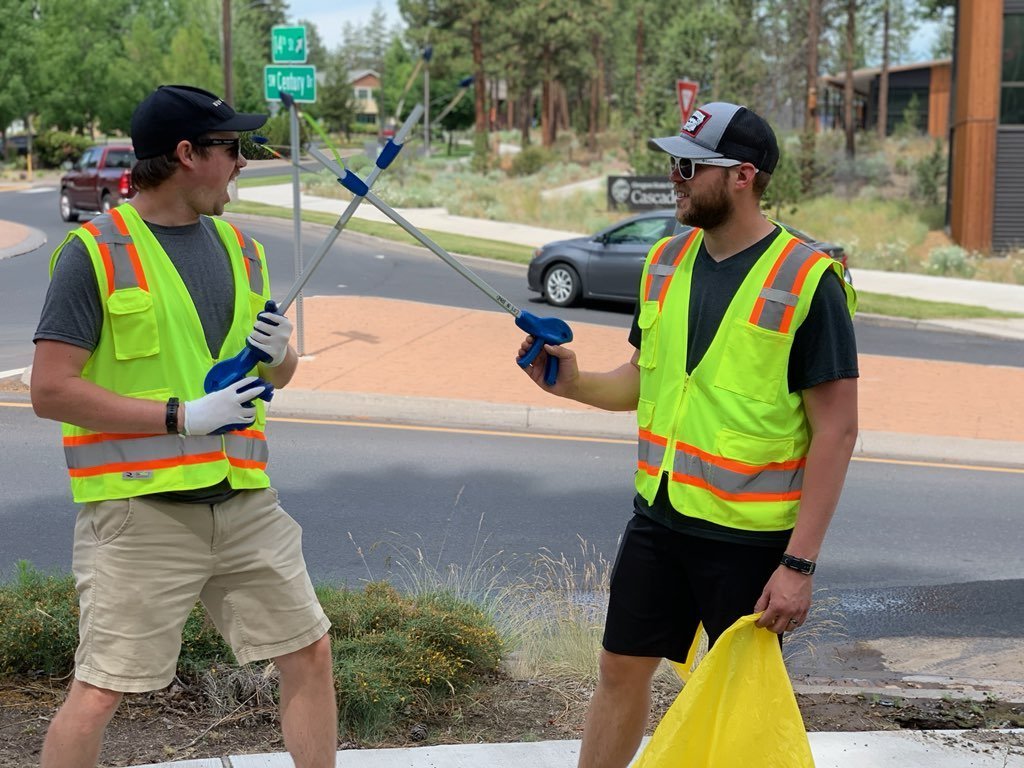
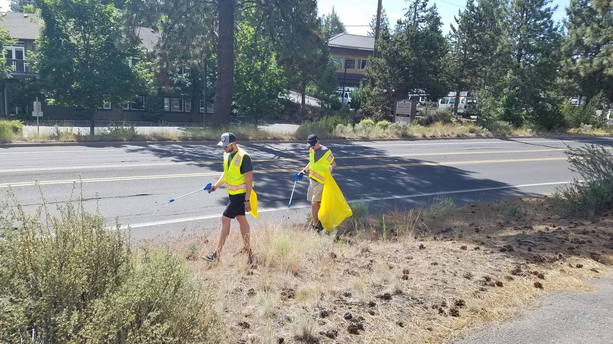
Bend Premier Real Estate Helps Keep Bend Beautiful
Bend Premier Brokers and Staff Volunteer
Over the weekend, Bend Premier got to be the first volunteer group to be a part of "Keeping Bend Beautiful" following the initial shut down due to COVID-19. This volunteer program allows various clubs, individuals, and associations the opportunity to adopt a stretch of road or plot of land and improve the appearance by picking up litter, weeding and sometimes planting new plants!
Bend Premier worked on picking up trash along 14th street on the Westside of Bend on Saturday and it was a wonderful experience. Not only did the team clean up all the trash found along the side of the road, but they also had a great time doing it. The volunteers agreed that they can't wait for the next opportunity to do their part in Keeping Bend Beautiful!
If you or a group you know wants to get more information on this program and how you can take part, follow this link HERE to direct you to the City of Bend webpage.
 |
 |
 |
 |
 |
 |
24
Cinder Hill Viewpoint Provides Newberry Crater Overview
Newberry National Volcanic Monument's Lesser Known Hikes
.JPG)
Most Central Oregonians know what a wonderful place to camp, fish, and hike Newberry National Volcanic Monument is. Paulina Falls and the Obsidian Trail are easy, short hikes to beautiful views and interesting geological formations and are well used by visitors to the monument. However, probably a hike few take is the Crater Rim Trail which is 21 miles in total length and traverses the entire rim of the crater. We have never taken the Crater Rim Trail all the way around, but we have hiked from Cinder Hill campground up to the Crater Rim Trail and 3/4 mile along this to the Cinder Hill Viewpoint several times. The elevation change from East Lake to the Crater Rim Trail is roughly 1000 feet, but it is fairly easy to hike this with multiple switchbacks helping. The majority of the hike is in the woods and the shade helps cool the trail. We tried to do this hike a month earlier, but there was too much snow and we lost the trail. .JPG)
The views from Cinder Hill are fabulous of East Lake with Paulina Lake also visible from the rim. When we were there on June 20th, there was some wind at the viewpoint and the temperature was much cooler than it was during the hike up in the more sheltered woods. The sign at the start of the hike shows 2 3/4 miles from the campground to the viewpoint which felt accurate. This is a great hike to take during the summer.
.JPG) |
.JPG) |
19
Painted Hills is Ready for Visitors
Painted Hills - Part of the John Day Fossil Beds National Monument
.JPG)
Known as one of the 7 Wonders of Oregon, the Painted Hills is series of hills with outstanding colors. Located roughly 86 miles northeast of Bend close to Mitchell, Oregon, the hills get their colors from the geology of the area over 35 million years. The combination of river flood plain, tropical forest, volcanic ash, and time has resulted in the color striations of the hills. Colors of red, green, orange, tan, and even lavender all provide a beautiful representation of millions of years of changing climate and geological upheavals. The hills monument cover over 3000 acres and are the most visited of the John Day Fossil Beds. Several easy hikes enable visitors to view the hills close up and from a distance. As the day goes on, the changing light and shadows as evening approaches can create an even more dramatic landscape to admire.
When we visited Painted Hills on 6-13-2020, we were pleased at the condition of the day use area directly outside the monument with clean, well stocked restrooms and a nicely mowed grass area with clean picnic tables. The trails were well defined and visitors were noted reading the signs explaining the geology of the area. The Painted Hills is a must see for anyone visiting Central Oregon.
.JPG) |
.JPG) |
.JPG) |
.JPG) |
7
Sparks Lake - June 7, 2020
Sparks Lake Not Yet Ready for Visitors
.jpg)
Sparks Lake is one of our favorite Central Oregon places to take visitors to showcase why we love where we live. Located off the Cascade Lakes Highway, the views of Broken Top and South Sister from the Ray Atkeson Memorial Trail are spectacular and the lake is usually filled with non-motorized boats and paddle boards during the summer months. It is one of our favorite places to go, especially since the Ray Atkeson Memorial Trail is handicap accessible which makes it a fabulous place for us to take elderly parents.
We drove up to Sparks Lake today hoping to catch some mountain views between the clouds and late snow showers. However, the views did not come out and the weather remained cool and overcast.