Posts in category 'Great Oregon Hikes'
Subscribe and receive email notifications of new blog posts.
 RSS Feed
- 2026 | 71 Posts
- 2025 | 103 Posts
- 2024 | 110 Posts
- 2023 | 72 Posts
- 2022 | 52 Posts
- 2021 | 70 Posts
- 2020 | 84 Posts
- 2019 | 38 Posts
- 2018 | 48 Posts
- 2017 | 39 Posts
- 2016 | 31 Posts
- 2015 | 10 Posts
18
Hiking From Todd Lake to No Name Lake on Broken Top: A Classic Bend Adventure
Why This Hike Tops the List
If you're looking for a high-country hike near Bend that delivers big rewards without being an all-day grind, the Todd Lake to No Name Lake route is hard to beat. It's a staple for locals and a must-do for hikers visiting Central Oregon. Clear views, striking geology, and a turquoise lake tucked under Broken Top's cliffs—this trail earns every bit of its reputation.
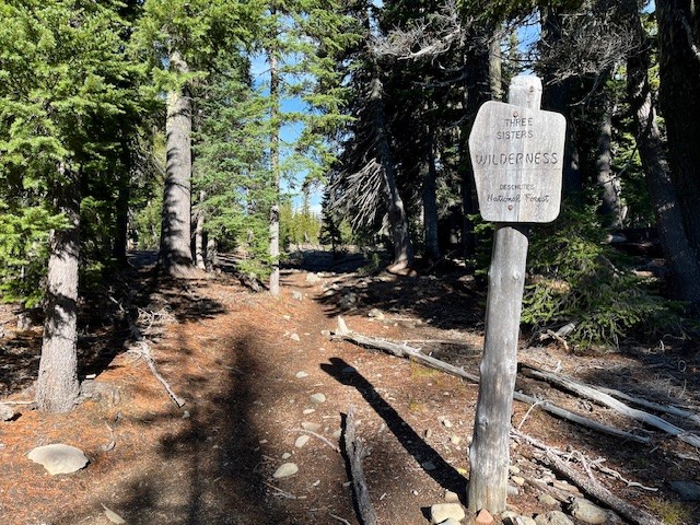
Trailhead: What to Know Before You Go
Todd Lake is the gateway to the high country and a gentle start to an otherwise rugged hike. Summer permits are required, and parking fills up early—no sense pretending luck will save you. Get there ahead of the crowd and you'll have a smoother day.
The hike begins with calm lakeside views, but you'll leave the easy terrain behind quickly. Plan for a steady climb and pack more water than you think you need. That rule never goes out of style in the Cascades.
 |
 |
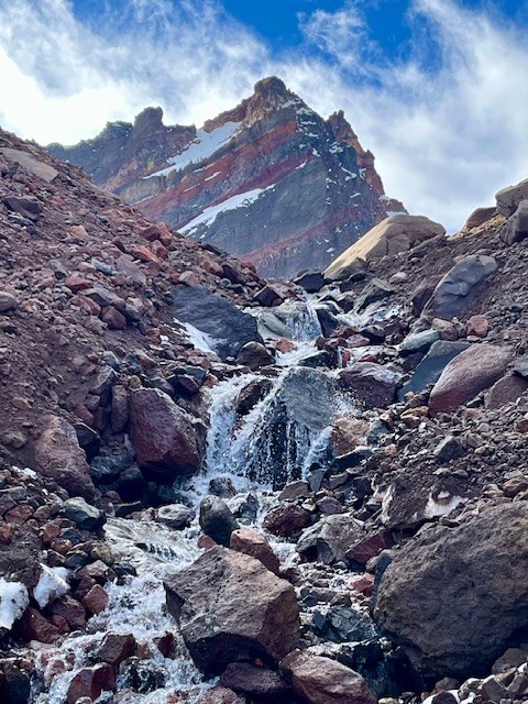
The Ascent Toward Broken Top
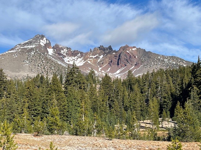
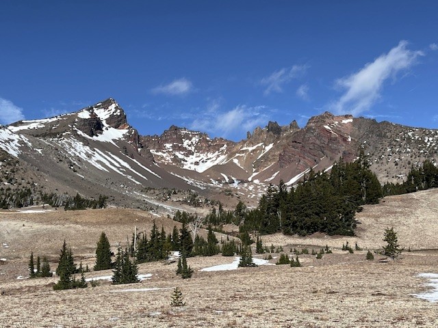
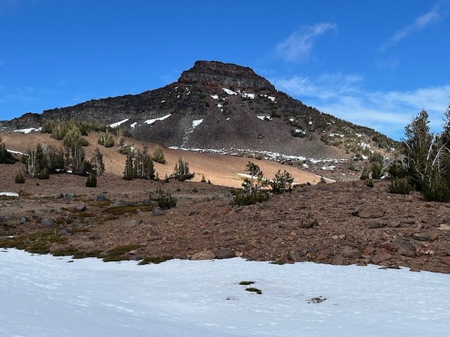
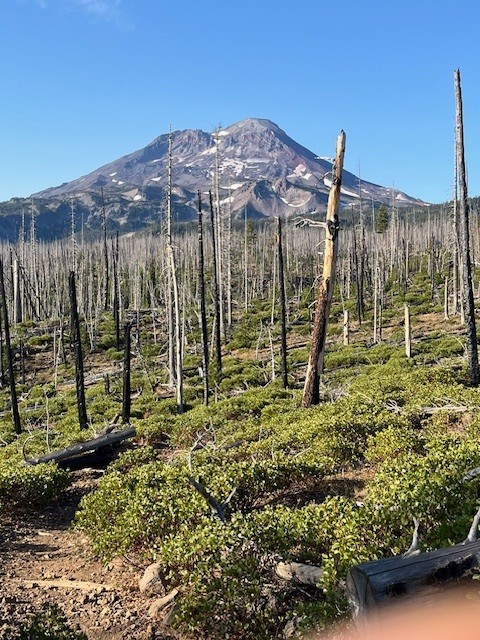
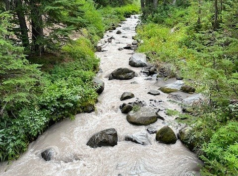
Once you climb out of the Todd Lake basin, the landscape immediately shifts. Broad alpine meadows open up with views that practically force you to stop. Wildflowers linger into late summer, and depending on the year, you might hit a few water crossings early in the season. Some are simple; some will test you and a short jaunt upstream may find a better crossing.
The trail continues uphill at a consistent grade—not brutal, but enough to remind you you're earning the views. As the trail climbs, you will see the bowl of Broken Top and Broken Hand next to Ball Butte.
 |
 |
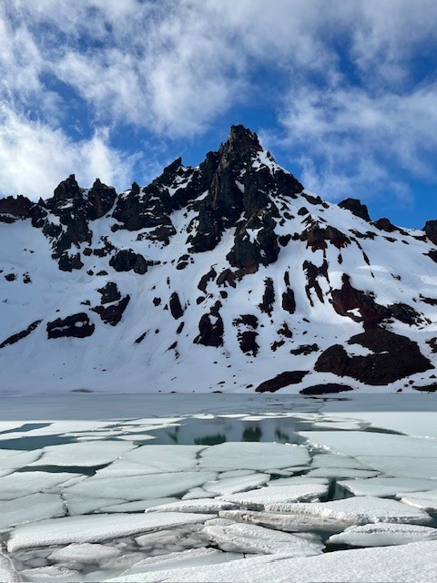
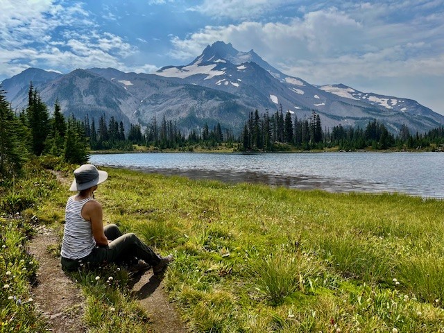
Arriving at No Name Lake
The payoff is no mystery. As soon as you crest that final rise, No Name Lake jumps into view with its glacial-blue water and the jagged summit of Broken Top looming overhead. It's dramatic, and it never gets old.
The wind at the lake can cut right through you, even on sunny days. Bring the extra layer. Most people wish they had. In mid November 2025, early snow melt can make for icy patches.
 |
 |
Optional Spur: The Ridgeline Viewpoint
If you've still got energy, take the short scramble above the lake. The vantage point gives you a panorama of South Sister, Mount Bachelor, Sparks Lake, and miles of wilderness you won't see from below. It's a quick effort with a huge return.
Heading Back
The descent is straightforward, but the dusty volcanic soil can get slick in summer. The meadows look completely different on the way down, especially in late-afternoon light, so the return trip isn't just a repeat.
Is This Hike Worth It? Absolutely.
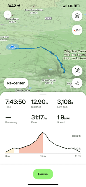
There's a reason people go back year after year. It's not technical but the scenery is top-tier. For anyone seeking a dependable alpine hike near Bend with big visual impact, Todd Lake to No Name Lake delivers. The entire trip exceeds 13 miles round trip and over 2500 feet of elevation gain if the Ridgeline Viewpoint is included.
Thinking About Moving to Bend?
If exploring trails like this is the lifestyle you want more of, Bend makes it easy. The area combines year-round outdoor access with a strong community with great real estate opportunities for varied budgets and housing needs. Call us to keep up with local trails, Bend living tips, and Central Oregon real estate insights.
30
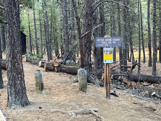
Fall Adventure on the Peter Skene Ogden Trail
Discovering Central Oregon's Hidden Waterfalls and Autumn Magic
There's nothing quite like fall in Central Oregon—the crisp air, golden larches, and that quiet sense of calm before winter settles in. This past weekend, we set out on one of the region's most beautiful hikes: the Peter Skene Ogden Trail, a forested path that winds along Paulina Creek between La Pine and Paulina Lake.
 There's nothing quite like fall in Central Oregon—the crisp air, golden larches, and that quiet sense of calm before winter settles in. This past weekend, we set out on one of the region's most beautiful hikes: the Peter Skene Ogden Trail, a forested path that winds along Paulina Creek between La Pine and Paulina Lake.
A Trail Rich in Scenery and History
Named after early explorer Peter Skene Ogden, this trail follows the rushing waters of Paulina Creek through towering pines and volcanic rock formations. The moment you step onto the trailhead, you're greeted by the earthy scent of pine needles and the muffled sound of water tumbling in the distance—nature's invitation to slow down and explore.
Autumn Colors in Full Glow
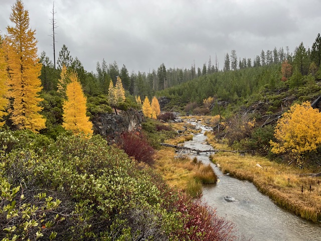
Mid-October is a spectacular time to visit. The larches were glowing gold, willows and huckleberries added bright pops of red, and the forest floor was carpeted in amber needles. Even under a soft drizzle, the landscape shimmered with color—proof that Oregon's magic isn't reserved for sunny days.
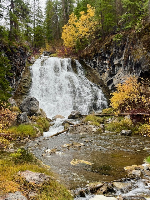
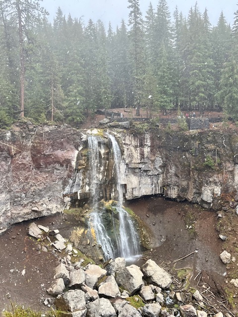
Waterfalls Around Every Bend
One of the highlights of the Peter Skene Ogden Trail is its string of waterfalls—each with its own character. Hikers can stop at several along the way:
- Lower Falls, where a broad curtain of water cascades dramatically over basalt cliffs.
- Paulina Creek Falls, a show-stopping finale that plunges nearly 80 feet into a rocky amphitheater below.
- And several smaller falls and pools in between, perfect for photos or a quiet break beside the creek.
 |
 |
Wooden bridges cross the stream at various points, offering postcard views and a chance to soak in the sound of rushing water echoing through the canyon.
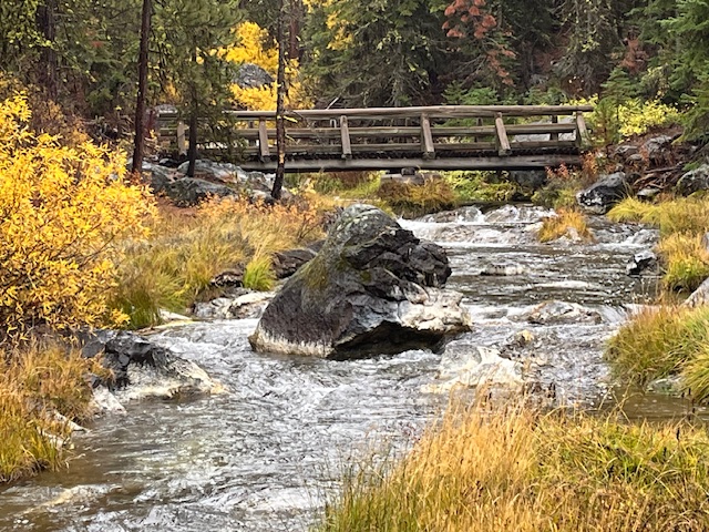 Wooden bridges cross the stream at various points, offering postcard views and a chance to soak in the sound of rushing water echoing through the canyon.
A True Central Oregon Gem
Whether you're a local looking for a quick escape or a visitor exploring beyond Bend, the Peter Skene Ogden Trail is a reminder of why we live here. It's less crowded than many popular Bend hikes, offers easy access to multiple waterfalls, and provides an ever-changing landscape from season to season.
If You Go
- Trailhead: Near McKay Crossing Campground (about 7 miles east of La Pine).
- Length: Roughly 7 miles one way to Paulina Lake, but you can hike shorter sections for a beautiful day trip.
- Best Season: Late spring through fall; expect snow at higher elevations by November.
- Tip: Bring layers, waterproof shoes, and a camera—you'll want to capture every turn of this gorgeous trail.
Why We Love Exploring Local Trails
Part of what makes Central Oregon special isn't just its homes and neighborhoods—it's the lifestyle that surrounds them. From mountain trails and alpine lakes to charming downtowns and cozy coffee shops, life here invites balance, adventure, and connection to nature.
3
Hike to Carl Lake and Beyond in Oregon's Mt Jefferson Wilderness
The Hike to Carl Lake is Little Known
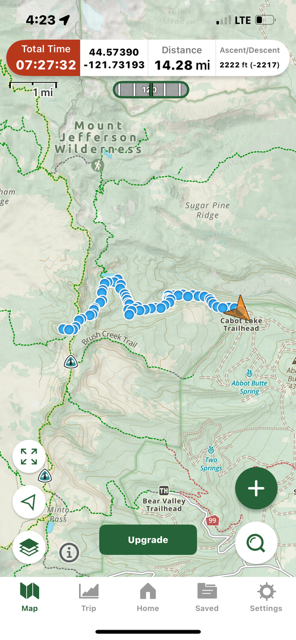
Many in Central Oregon know of the hike to Three Fingered Jack via Canyon Meadow. This trailhead to this hike is accessed from Jack Lake which is at the end of Forest Service Road 1234 in the Mt Jefferson Wilderness. Forest Service Road 1234 splits off Forest Service Road 1230 roughly two miles off paved Jack Lake Road. If instead of turning on 1234 to the Jack Lake Trailhead, people wanting a different experience can continue on 1230 for seven miles to reach the Cabot Lake (Carl Lake) trailhead (the last two miles of this road is rough).
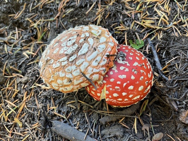
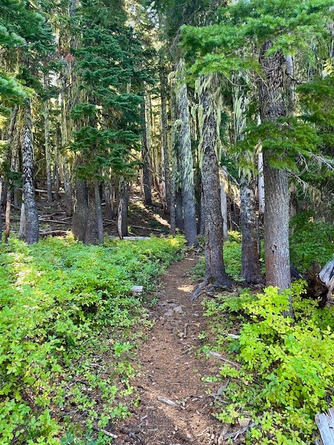
The first mile and a half of this hike is through the recovering burned forest of the B & B complex fire of 2003, but after that, the hike is in old growth forest. Two miles in the trail passes an overgrown and uncleared spur that can take hikers to Cabot Lake, a lovely forest lake. The trail has numerous blueberry bushes and in the fall, interesting mushrooms. After a series of switchbacks climbing a ridge, the trail levels out and passes three small unnamed lakes until at five miles the trail reaches Carl Lake.
 |
 |
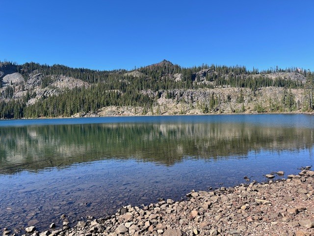
Carl Lake is a lovely, deep blue, glaciated, trout filled alpine lake. There are also many camping spots dotted around the lake for those who wish to spend some time enjoying the area. For those wishing more hiking challenges, past the south side of the lake is a trail that goes to Shirley Lake and beyond it, climbs to reach the Pacific Crest Trail. Two tenths of a mile south on the PCT is a spur trail trail west that hikers can use to summit South Cinder Cone. For those who do, the views toward Mt. Jefferson to the north and Three Fingered Jack to the south are truly outstanding.
 |
 |
Day hikers can enjoy the entire trip from the trailhead up South Cinder Cone and back in 14.28 miles and see very few if any people.
 |
 |
22
Hayden Glacier Hike on Middle Sister is a Challenge
Take the Climbers' Trail to Reach Hayden Glacier
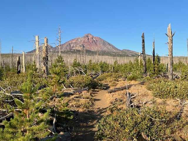
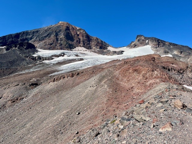
For Central Oregon hikers looking for something different that does not require a paid permit, the climbers' trail on Middle Sister is well worth it. Most hikers would start in the burned forest at the Pole Creek Trailhead located off forest service road 15 outside of Sisters (the parking at the trailhead requires $5 payment or a forest pass). After hiking the trail to the junction with Green Lakes Trail 17, trekkers continue on Trail 17 toward Park Meadow. Shortly after crossing Soap Creek is the junction with Camp Lake which hikers should take to reach the unmarked junction with the Climbers' Trail. If hikers miss this trail, it loops with another section of the Camp Lake trail near one of the branches of Wychus Creek which hikers to Camp Lake have to cross. Climbers don't cross the creek, but instead hike upstream toward Middle Sister.
Regardless of the looped trail route chosen, they join on the moraine just under Hayden Glacier. Both are steep, difficult hikes with loose pumice and boulders to traverse. For those who plan on summiting Middle or North Sister, Hayden Glacier is just another geological feature to pass by before the summiting. For those not wishing to go further, the Cascade views from the glacier are amazing.
For those starting at the Pole Creek Trailhead and hiking to the glacier but no further, plan on a full day, climbing over 3100 feet and roughly 13 miles.
 |
 |
 |
 |
4
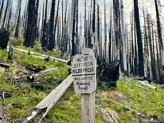
Jefferson Park in the Mt Jefferson Wilderness is Still Beautiful Despite Fires
Two Fires in Eight Years Have Impacted Jefferson Park
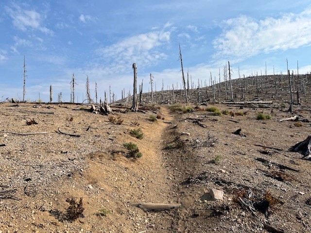
For those who enjoy hiking in the Mt. Jefferson Wilderness, one of the most treasured locations to see has been Jefferson Park. Located at the base of Mt. Jefferson, Oregon's second tallest peak, the beauty of the meadow and the reflection of Mt. Jefferson in the multiple lakes has been the destination for campers and day hikers for many years. In 2017, the Whitewater Fire destroyed 11,500 acres, much of which was near the Whitewater trailhead and surrounding forest. However, in 2020, the devastating Santiam Fire, which ballooned to 402,274 acres and destroyed several towns, over 1500 structures and killed 5 people was among the worst fires in Oregon's history. Access to Jefferson Park remained closed for several years after this fire, but has since reopened.
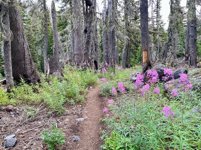
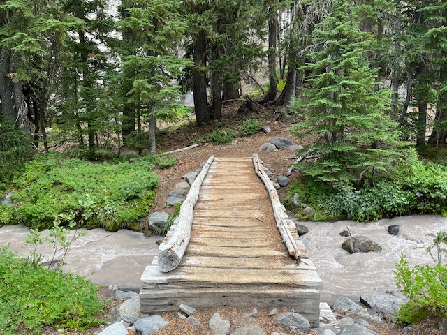
The hike to Jefferson Park from the Whitewater trailhead takes hikers through 4 miles of burned forest before coming to Whitewater Creek where hikers need to cross via stones or logs laid across the creek. There are signs of life returning to the burned area, although it will take many decades before the forest is restored to what it was before the fires. The Whitewater trail joins with the Pacific Crest Trail before reaching the park and once again hikers have to cross Whitewater Creek, this time via a bridge.
 |
 |
 |
 |
It is shortly after crossing the bridge that hikers actually enter the meadow which is Jefferson Park. There are sections of the surrounding forest that are burned, but also many sections which remain beautiful and alive. Several side paths provide access to Bay, Scout, Park and Rock Lakes, all clean and clear alpine lakes with sandy bottoms with many camping areas nearby. Russell Lake is at the far western end of the park and provides outstanding reflections of Mt. Jefferson. There are campsites around Russell Lake as well. For those who hike from the Whitewater Trailhead to Russell Lake and back, plan on 13 miles and over 2300 feet of elevation gain.
 |
 |