Bend Premier Real Estate Blog
Subscribe and receive email notifications of new blog posts.
 RSS Feed
- 2026 | 67 Posts
- 2025 | 103 Posts
- 2024 | 110 Posts
- 2023 | 72 Posts
- 2022 | 52 Posts
- 2021 | 70 Posts
- 2020 | 84 Posts
- 2019 | 38 Posts
- 2018 | 48 Posts
- 2017 | 39 Posts
- 2016 | 31 Posts
- 2015 | 10 Posts
4
How the Federal Reserve's Next Move Could Impact the Housing Market
Now that it's September, all eyes are on the Federal Reserve (the Fed). The overwhelming expectation is that they'll cut the Federal Funds Rate at their upcoming meeting, driven primarily by recent signs that inflation is cooling, and the job market is slowing down. Mark Zandi, Chief Economist at Moody's Analytics, said:
"They're ready to cut, just as long as we don't get an inflation surprise between now and September, which we won't."
But what...
29
Are We Heading into a Balanced Market?
If you've been keeping an eye on the housing market over the past couple of years, you know sellers have had the upper hand. But is that going to shift now that inventory is growing? Here's a breakdown of what you need to know.
What Is a Balanced Market?
A balanced market is generally defined as a market with about a five-to-seven-month supply of homes available for sale. In this type of market, neither buyers nor sellers have a clear advantage. Prices tend to stabilize, and there's a healthier number of
26
What Mortgage Rate Are You Waiting For?
You won't find anyone who's going to argue that mortgage rates have had a big impact on housing affordability over the past couple of years. But there is hope on the horizon. Rates have actually started to come down. And, recently they hit the lowest point we've seen in 2024, according to Freddie Mac (see graph below):
21
Golden Lake is a Hidden Treasure in the Three Sisters Wilderness
Golden Lake is Not an Easy Hike
For Central Oregon residents and visitors looking for a great day hike, there are a good number of options available. For many, a hike of 2 to 4 miles to an amazing destination followed by the same distance back can create a full day with time to relax and enjoy both the original destination and the time back home. However, for those wishing to see more in the Cascade forests besides what is seen in a day hike, many will backpack and spend more time enjoying the destination before venturing further or coming back.
Golden Lake is one of those rarely seen destinations. It can be accessed through multiple approaches. These include the popular Green Lakes Trail in which hikers walk past the northern most Green Lake and travel above the valley to the pass between South Sister and Broken Top and then down the path that leads to Park Meadow, making sure they take the unmarked trail off this path and hike the half mile to Golden Lake. Another approach is from Three Creeks Lake, taking the Park Meadow trail and hiking through and past Park Meadow towards Green Lakes and then taking the unmarked trail to Golden Lake. Both approaches are over seven miles one direction, but the approach from Three Creeks Lake is a little shorter.
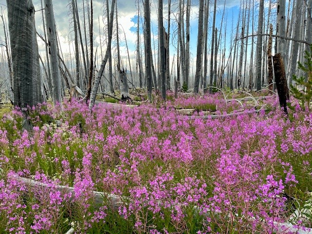
Hikers coming from Three Creeks Lake are required to walk through four miles of burned forest, the result of the Milli Fire seven years ago. There is beauty, however, in the recovering forest with many wildflowers and young trees growing back. Past the burned area, hikers enter forest before they reach Park Meadow, which was untouched by fire and a place many backpackers will spend the night. The trail steepens past park Meadow and after another mile and a half, the turn off to Golden Lake is reached.
 |
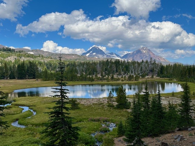 |
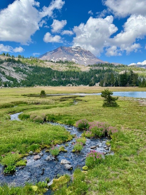
The name for Golden Lake is obvious during certain times of the year when yellow wildflowers are blooming in the meadow that surrounds the lake. The lake itself can reflect Broken Top, South, Middle and North Sisters on calm days. The setting is serene and lovely with very few people around.
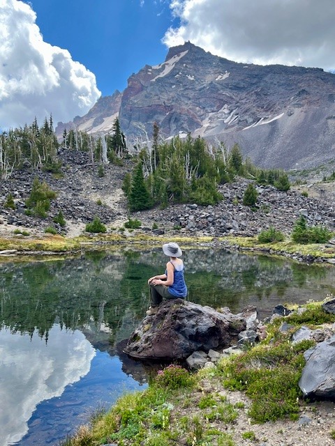
However, one of the most special things about Golden Lake is the small stream which flows into the western side of the lake. Besides the numerous wildflowers growing on each side of the stream, people who take the time to hike the mile up that stream reach an isolated area that very few people ever visit. That last mile is steep, but the cascading stream with its wildflowers and ever changing views of the Three Sisters are amazing. At the end of the stream is a moraine which contains two springs which form the stream. People who scramble up the moraine will reach an isolated tarn lake and past that, another moraine and a second tarn lake even more special than the first. This second lake has phenomenal reflections and views of Broken Top. For those who are able to travel the entire distance, the reward can be some of the most breathtaking natural sights in Central Oregon. It is truly an exceptional place.
For those having enough energy to do the entire hike in a day starting from and returning to Three Creeks Lake, plan on sixteen miles (eight in the burned forest) and over 2000 feet of elevation gain.
 |
 |
21
The Number One Mistake Sellers Are Making: Overpricing Their House
In today's Bend housing market, many sellers are making a critical mistake: overpricing their houses. This common error can lead to a home sitting on the market for a long time without any offers. And when that happens, the homeowner may have to drop their asking price to try to re-ignite buyer interest.
Data from Realtor.com shows the number of homeowners realizing this mistake and doi...