Bend Premier Real Estate Blog
Subscribe and receive email notifications of new blog posts.
 RSS Feed
- 2026 | 70 Posts
- 2025 | 103 Posts
- 2024 | 110 Posts
- 2023 | 72 Posts
- 2022 | 52 Posts
- 2021 | 70 Posts
- 2020 | 84 Posts
- 2019 | 38 Posts
- 2018 | 48 Posts
- 2017 | 39 Posts
- 2016 | 31 Posts
- 2015 | 10 Posts
6
Bend Premier Real Estate | December 2024 Newsletter
What's in the December 2024 Bend Premier Newsletter?
- More Inventory Means More Choices for Bend Homebuyers
- Eggnog Pie
- The Dos and Don'ts for Holiday Decorating When Selling
- Hike to Paulina Falls in Winter for a Truly Unique Experience
- Ready to Sell in 2025
6
Bend Oregon Real Estate | November 2024 Trends
More Inventory Means More Choices for Bend Home Buyers
There are more homes on the market for potential Bend home buyers to choose from than there were at the same time last year. With more inventory, there has been more motivation for sellers to negotiate price and terms with buyers. This in turn has resulted in homes selling for less than asking price, often after price reductions, in order to generate offers. While the overall sales price is up slightly over the same time last year, the months of supply is up over 11%.
When the data from November 2024 for Bend single family home sales on less than an acre is compared with those from November 2023, the following changes can be seen:
- Average sales price up 4.1% to $888,821
- Median sales price up 2.6% to $711,875
4
When Will Mortgage Rates Come Down?
One of the biggest questions on everyone's minds right now is: when will mortgage rates come down? After several years of rising rates and a lot of bouncing around in 2024, we're all eager for some relief.
While no one can project where rates will go with complete accuracy or the exact timing, experts offer some insight into what we might see going into next year. Here's what the latest forecasts show.
Mortgage Rates Are Expected To Ease and Stabilize in 2025
After a lot of volatility and uncertainty, the most updated forecasts suggest
2
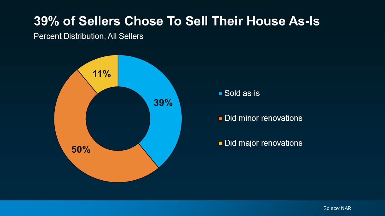
Should You Sell Your House As-Is or Make Repairs?
A recent study from the National Association of Realtors (NAR) shows most sellers (61%) completed at least minor repairs when selling their house. But sometimes life gets in the way and that's just not possible. Maybe that's why, 39% of sellers chose to sell as-is instead (see chart below):
 If you're feeling stressed...
20
What's Behind Today's Mortgage Rate Volatility?
If you've been keeping an eye on mortgage rates lately, you might feel like you're on a roller coaster ride. One day rates are up; the next they dip down a bit. So, what's driving this constant change? Let's dive into just a few of the major reasons why we're seeing so much volatility, and what it means for you.
The Market's Reaction to the Election
A significant factor causing fluctuations in mortgage rates is the general reaction to the political landscape. Election seasons often bring uncertainty to financial markets, and this one is no diff...